|
|
Antenna Structure Registration 1058295 |
 |
Registration Info | Registration Number: 1058295 |
| File Number: A1075456 |
| FAA Study: 2002-AWP-3749-OE |
| FAA Issue Date: 12/18/2002 |
| Status: Constructed |
| Date Constructed: 03/01/1999 |
| NEPA: N |
Structure Info
| Structure Type: LTOWER |
| Structure Coordinates: 36-0-34.2 N 115-0-22.1 W (NAD 83) |
| Structure Coordinates: 36-00-34.3 N 115-00-19.1 W (Converted to NAD 27) |
| Structure Address: Black Mtn., Black Mountain Rd., .7 Mi. W Of I-515 (black Mtn T9 #90349--can) |
| Structure City: Henderson, NV |
| Structure County: Clark County |
| Painting & Lighting Info |
FAA Chapters: NONE |
Remarks: PRIOR STUDY 2002-AWP-3748-OE |
| Elevation Info |
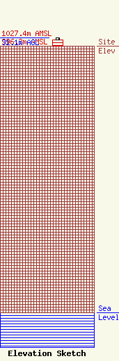
Site Elevation: 996.3 meters (3269 ft) |
| Height of Structure: 24.4 meters (80 feet) |
| Overall Height Above Ground: 31.1 meters (102 feet) |
| Overall Height Above Mean Sea Level: 1027.4 meters (3371 feet) |
| C/R Height Above Mean Sea Level: 1011.5 meters (3319 ft)
|
| Owner Info | American Towers LLC
10 Presidential Way
Woburn, MA 01801
(781) 926-4500
faa-fcc@americantower.com |
| Contact Info | American Towers, LLC
10 Presidential Way
Woburn, MA 01801
(781) 926-4500
faa-fcc@americantower.com |
