|
|
Antenna Structure Registration 1260366 |
 |
Registration Info | Registration Number: 1260366 |
| File Number: A1285813 |
| FAA Study: 2024-AWP-5892-OE |
| FAA Issue Date: 05/28/2024 |
| Status: Constructed |
| Date Constructed: 03/12/2002 |
| NEPA: N |
Structure Info
| Structure Type: LTOWER |
| Structure Coordinates: 32-59-39.4 N 115-4-11.6 W (NAD 83) |
| Structure Coordinates: 32-59-39.2 N 115-04-08.7 W (Converted to NAD 27) |
| Structure Address: 5384 E. Highway 78 (ca10507-a) |
| Structure City: Brawley, CA |
| Structure County: Imperial County |
| Painting & Lighting Info |
FAA Chapters: NONE |
Remarks: PRIOR STUDY 2011-AWP-3839-OE |
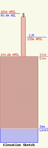
| Elevation Info |
Site Elevation: 100.6 meters (330 ft) |
| Height of Structure: 55.8 meters (183 feet) |
| Overall Height Above Ground: 60.4 meters (198 feet) |
| Overall Height Above Mean Sea Level: 161 meters (528 feet) |
| C/R Height Above Mean Sea Level: 128 meters (420 ft)
|
| Owner Info | SBA Towers II LLC
8051 Congress Avenue
Boca Raton, FL 33487
(561) 995-7670
ERoach@sbasite.com |
| Contact Info | SBA Towers II LLC
8051 Congress Avenue
Boca Raton, FL 33487
(561) 995-7670
ERoach@sbasite.com |
