|
|
Antenna Structure Registration 1029642 |
 |
Registration Info | Registration Number: 1029642 |
| File Number: A1248823 |
| FAA Study: 92-ASO-0515-OE |
| Status: Constructed |
| Date Constructed: 03/01/1994 |
| NEPA: N |
Structure Info
| Structure Type: TOWER |
| Structure Coordinates: 33-56-48.0 N 90-50-58.0 W (NAD 83) |
| Structure Coordinates: 33-56-47.6 N 90-50-57.6 W (Converted to NAD 27) |
| Structure Address: St Hwy 32 18.8 Km Nnw Of Cleveland |
| Structure City: Pertshire, MS |
| Structure County: Bolivar County |
| Painting & Lighting Info |
FAA Circular #: 70/7460-1H |
FAA Chapters: 3, 4, 5, 13 |
| Elevation Info |
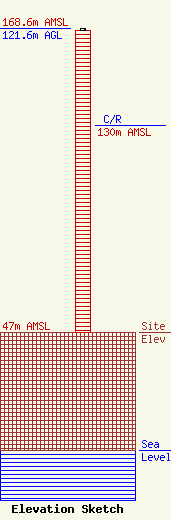
Site Elevation: 47 meters (154 ft) |
| Height of Structure: 121 meters (397 feet) |
| Overall Height Above Ground: 121.6 meters (399 feet) |
| Overall Height Above Mean Sea Level: 168.6 meters (553 feet) |
| C/R Height Above Mean Sea Level: 130 meters (427 ft)
|
| Owner Info | Radio Cleveland, Inc. DBA WMJW RADIO
780
CLEVELAND, MS 38732
(662) 843-4091
kwc514@yahoo.com |
| Contact Info | Wilkinson Barker Knauer, LLP
1800 M Street, NW
Washington, DC 20036
Davina Sashkin
(202) 383-3428
dsashkin@wbklaw.com |
