|
|
Antenna Structure Registration 1279739 |
 |
Registration Info | Registration Number: 1279739 |
| File Number: A0732415 |
| FAA Study: 2009-AGL-4620-OE |
| FAA Issue Date: 05/27/2010 |
| Status: Granted |
| NEPA: N |
Structure Info
| Structure Type: TOWER |
| Structure Coordinates: 39-58-39.7 N 84-19-42.4 W (NAD 83) |
| Structure Coordinates: 39-58-39.5 N 84-19-42.6 W (Converted to NAD 27) |
| Structure Address: 4800 South State Route 48 |
| Structure City: West Milton, OH |
| Structure County: Miami County |
| Painting & Lighting Info |
FAA Circular #: |
FAA Chapters: NONE |
Remarks: Removed expiration date from determination. Scenario 1./jjs/case#635066 |
| Elevation Info |
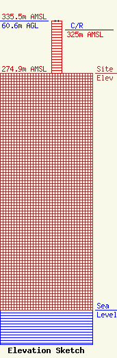
Site Elevation: 274.9 meters (902 ft) |
| Height of Structure: 60.5 meters (198 feet) |
| Overall Height Above Ground: 60.6 meters (199 feet) |
| Overall Height Above Mean Sea Level: 335.5 meters (1101 feet) |
| C/R Height Above Mean Sea Level: 325 meters (1066 ft)
|
| Owner Info | Miami County Board of Commissioners
201 West Main Street
Troy, OH 45373
(937) 440-5900
|
| Contact Info | Miami County Communication Center
210 Marybill Drive
Troy, OH 45373
Jeffrey Busch
(937) 332-7631
director@mccc.co.miami.oh.us |
