|
|
Antenna Structure Registration 1017945 |
 |
Registration Info | Registration Number: 1017945 |
| File Number: A1128015 |
| FAA Study: 2018-ACE-5050-OE |
| FAA Issue Date: 08/08/2018 |
| Status: Constructed |
| Date Constructed: 04/21/1994 |
| NEPA: N |
Structure Info
| Structure Type: GTOWER |
| Structure Coordinates: 41-3-55.7 N 92-50-47.2 W (NAD 83) |
| Structure Coordinates: 41-03-55.7 N 92-50-46.5 W (Converted to NAD 27) |
| Structure Address: 1662 631st Lane (395299) |
| Structure City: Albia, IA |
| Structure County: Monroe County |
| Painting & Lighting Info |
FAA Circular #: 70/7460-1H |
FAA Chapters: 4, 8, 13 |
Remarks: OM&L to remain the same as prior study = A MED-DUAL SYSTEM |
Remarks: PRIOR STUDY 1994-ACE-199-OE |
Remarks: OM&L to remain the same as prior study = A MED-DUAL SYSTEM |
Remarks: PRIOR STUDY 1994-ACE-199-OE |
| Elevation Info |
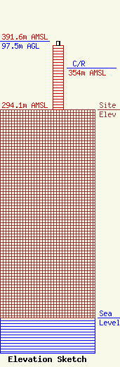
Site Elevation: 294.1 meters (965 ft) |
| Height of Structure: 91.4 meters (300 feet) |
| Overall Height Above Ground: 97.5 meters (320 feet) |
| Overall Height Above Mean Sea Level: 391.6 meters (1285 feet) |
| C/R Height Above Mean Sea Level: 354 meters (1161 ft)
|
| Owner Info | Alltel Corporation
5055 North Point Pkwy
Alpharetta, GA 30022
(770) 797-1070
Network.Regulatory@verizonwireless.com |
| Contact Info | Alltel Corporation
5055 North Point Pkwy
Alpharetta, GA 30022
Regulatory Manager
(770) 797-1070
Network.Regulatory@verizonwireless.com |
