|
|
Antenna Structure Registration 1300127 |
 |
Registration Info | Registration Number: 1300127 |
| File Number: A1275240 |
| FAA Study: 2023-AGL-22957-OE |
| FAA Issue Date: 12/06/2023 |
| Status: Constructed |
| Date Constructed: 09/28/2016 |
| FAA EMI: Y |
Structure Info
| Structure Type: GTOWER |
| Structure Coordinates: 43-43-41.2 N 88-46-22.1 W (NAD 83) |
| Structure Coordinates: 43-43-41.3 N 88-46-21.7 W (Converted to NAD 27) |
| Structure Address: 612 County Rd Ter |
| Structure City: Brandon, WI |
| Structure County: Fond du Lac County |
| Painting & Lighting Info |
FAA Circular #: 70/7460-1L |
FAA Chapters: 4, 8, 12 |
Remarks: PRIOR STUDY 2022-AGL-1568-OE |
Remarks: OM&L to remain the same as prior study = A MED-DUAL SYSTEM |
Remarks: PRIOR STUDY 2022-AGL-1568-OE |
Remarks: OM&L to remain the same as prior study = A MED-DUAL SYSTEM |
| Elevation Info |
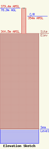
Site Elevation: 300.5 meters (986 ft) |
| Height of Structure: 78.9 meters (259 feet) |
| Overall Height Above Ground: 78.9 meters (259 feet) |
| Overall Height Above Mean Sea Level: 379.4 meters (1245 feet) |
| C/R Height Above Mean Sea Level: 354 meters (1161 ft)
|
| Owner Info | UNITED STATES CELLULAR CORPORATION
8410 W. Bryn Mawr Ave, Suite 700
CHICAGO, IL 60631-3486
(800) 510-6091
REGULATORYAFFAIRS@USCELLULAR.COM |
| Contact Info | Wilkinson Barker Knauer, LLP
1800 M Street NW, Suite 800N
Washington, DC 20036
GLENN WERNER
(202) 383-3420
GWERNER@WBKLAW.COM |
