|
|
Antenna Structure Registration 1223523 |
 |
Registration Info | Registration Number: 1223523 |
| File Number: A1306671 |
| FAA Study: 2024-AGL-16372-OE |
| FAA Issue Date: 11/29/2024 |
| Status: Constructed |
| Date Constructed: 04/10/2006 |
| NEPA: N |
Structure Info
| Structure Type: GTOWER |
| Structure Coordinates: 44-57-30.2 N 90-46-28.8 W (NAD 83) |
| Structure Coordinates: 44-57-30.3 N 90-46-28.3 W (Converted to NAD 27) |
| Structure Address: W9177 County Trunk Highway X (thorp #050573) |
| Structure City: Thorp, WI |
| Structure County: Clark County |
| Painting & Lighting Info |
FAA Circular #: 70/7460-1K |
FAA Chapters: 4, 8, 12 |
Remarks: OM&L to remain the same as prior study = A MED-DUAL SYSTEM |
Remarks: PRIOR STUDY 2007-AGL-554-OE |
Remarks: OM&L to remain the same as prior study = A MED-DUAL SYSTEM |
Remarks: PRIOR STUDY 2007-AGL-554-OE |
| Elevation Info |
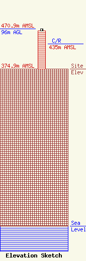
Site Elevation: 374.9 meters (1230 ft) |
| Height of Structure: 91.7 meters (301 feet) |
| Overall Height Above Ground: 96 meters (315 feet) |
| Overall Height Above Mean Sea Level: 470.9 meters (1545 feet) |
| C/R Height Above Mean Sea Level: 435 meters (1427 ft)
|
| Owner Info | American Towers LLC
10 Presidential Way
Woburn, MA 01801
(781) 926-4500
faa-fcc@americantower.com |
| Contact Info | American Towers LLC
10 Presidential Way
Woburn, MA 01801
(781) 926-4500
faa-fcc@americantower.com |
