|
|
Antenna Structure Registration 1037059 |
 |
Registration Info | Registration Number: 1037059 |
| File Number: A1019833 |
| FAA Study: 97-ACE-0821-OE |
| Status: Constructed |
| Date Constructed: 11/06/1997 |
| FAA EMI: N |
| NEPA: N |
Structure Info
| Structure Type: TOWER |
| Structure Coordinates: 42-36-18.0 N 90-47-57.0 W (NAD 83) |
| Structure Coordinates: 42-36-18.0 N 90-47-56.5 W (Converted to NAD 27) |
| Structure Address: 15824 Haberkorn Rd Lot 3 |
| Structure City: Sherrill, IA |
| Structure County: Dubuque County |
| Painting & Lighting Info |
FAA Circular #: 70/7460-1J |
FAA Chapters: 3, 4, 5, 13 |
| Elevation Info |
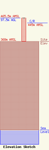
Site Elevation: 368 meters (1207 ft) |
| Height of Structure: 97.5 meters (320 feet) |
| Overall Height Above Ground: 97.5 meters (320 feet) |
| Overall Height Above Mean Sea Level: 465.5 meters (1527 feet) |
| C/R Height Above Mean Sea Level: 445 meters (1460 ft)
|
| Owner Info | Pinnacle Towers LLC
2000 Corporate Drive
Canonsburg, PA 15317
(724) 416-2000
Regulatory.Department@Crowncastle.com |
| Contact Info | Crown Castle
2000 Corporate Drive
Canonsburg, PA 15317
Don Snyder
(724) 416-2470
Don.Snyder@crowncastle.com |
