|
|
Antenna Structure Registration 1211932 |
 |
Registration Info | Registration Number: 1211932 |
| File Number: A0839261 |
| FAA Study: 2005-ANM-1407-OE |
| FAA Issue Date: 07/14/2005 |
| Status: Constructed |
| Date Constructed: 04/23/2009 |
| FAA EMI: N |
Structure Info
| Structure Type: LTOWER |
| Structure Coordinates: 43-44-12.4 N 123-9-32.7 W (NAD 83) |
| Structure Coordinates: 43-44-13.0 N 123-09-28.4 W (Converted to NAD 27) |
| Structure Address: 2200 North Bear Creek Road (308287 / Cottage Grove Or 6) |
| Structure City: Cottage Grove, OR |
| Structure County: Douglas County |
| Painting & Lighting Info |
FAA Chapters: NONE |
Remarks: PRIOR STUDY 2003-ANM-706-OE |
| Elevation Info |
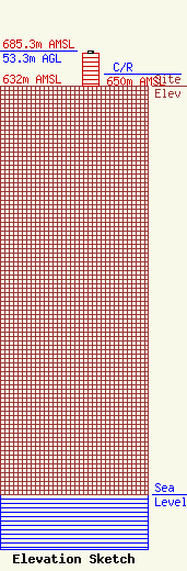
Site Elevation: 632 meters (2073 ft) |
| Height of Structure: 50.3 meters (165 feet) |
| Overall Height Above Ground: 53.3 meters (175 feet) |
| Overall Height Above Mean Sea Level: 685.3 meters (2248 feet) |
| C/R Height Above Mean Sea Level: 650 meters (2133 ft)
|
| Owner Info | SpectraSite Communications, LLC. through American Towers, LLC.
10 Presidential Way
Woburn, MA 01801
(678) 564-3236
faa-fcc@americantower.com |
| Contact Info | SpectraSite Communications, LLC. through American Towers, LLC.
10 Presidential Way
Woburn, MA 01801
(678) 564-3236
faa-fcc@americantower.com |
