|
|
Antenna Structure Registration 1000709 |
 |
Registration Info | Registration Number: 1000709 |
| File Number: A0000863 |
| FAA Study: 95-ANM-0776-OE |
| FAA Issue Date: 10/13/1995 |
| Status: Constructed |
| Date Constructed: 03/31/1996 |
| NEPA: N |
Structure Info
| Structure Type: BTWR |
| Structure Coordinates: 45-46-58.0 N 108-30-14.0 W (NAD 83) |
| Structure Coordinates: 45-46-58.2 N 108-30-11.5 W (Converted to NAD 27) |
| Structure Address: 27 N 27th St |
| Structure City: Billings, MT |
| Structure County: Yellowstone County |
| Painting & Lighting Info |
FAA Circular #: 70/7460-1J |
FAA Chapters: 3, 4, 5, 13 |
| Elevation Info |
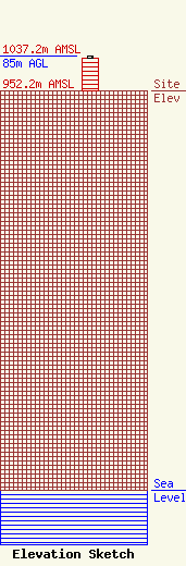
Site Elevation: 952.2 meters (3124 ft) |
| Height of Structure: 77.4 meters (254 feet) |
| Overall Height Above Ground: 85 meters (279 feet) |
| Overall Height Above Mean Sea Level: 1037.2 meters (3403 feet) |
| Owner Info | HARRIS, STEPHEN R DBA = HARRIS BROADCASTING CO INC
417 W PLUMB LN
RENO, NV 89509
(702) 786-7600
|
