|
|
Antenna Structure Registration 1000732 |
 |
Registration Info | Registration Number: 1000732 |
| File Number: A1096332 |
| FAA Study: 2015-AGL-7536-OE |
| FAA Issue Date: 09/22/2015 |
| Status: Constructed |
| Date Constructed: 11/01/1990 |
| NEPA: N |
Structure Info
| Structure Type: GTOWER |
| Structure Coordinates: 46-39-49.5 N 88-23-6.4 W (NAD 83) |
| Structure Coordinates: 46-39-49.7 N 88-23-05.9 W (Converted to NAD 27) |
| Structure Address: 1 Mi Sw |
| Structure City: Herman, MI |
| Structure County: Baraga County |
| Painting & Lighting Info |
FAA Circular #: 70/7460-1K |
FAA Chapters: 4, 8, 12 |
Remarks: FAA CHAPTERS 4,8,12; 70/7460-1K WITH BIRD LIGHTING DEVIATION SPECIAL CONDITION. PRIOR STUDY 2007-AGL-6194-OE |
| Elevation Info |
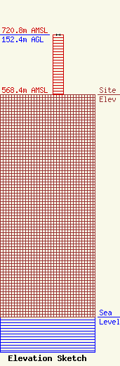
Site Elevation: 568.4 meters (1865 ft) |
| Height of Structure: 152.4 meters (500 feet) |
| Overall Height Above Ground: 152.4 meters (500 feet) |
| Overall Height Above Mean Sea Level: 720.8 meters (2365 feet) |
| Owner Info | VB-S1 Assets, LLC
750 Park of Commerce Dr.
Boca Raton, FL 33487
(561) 406-4015
FCC-FAA@verticalbridge.com |
| Contact Info | VB-S1 Assets, LLC
750 Park of Commerce Dr.
Boca Raton, FL 33487
Richard Hickey
(561) 406-4015
FCC-FAA@verticalbridge.com |
