|
|
Antenna Structure Registration 1000758 |
 |
Registration Info | Registration Number: 1000758 |
| File Number: A1152158 |
| FAA Study: 83-ASO-108-OE |
| FAA Issue Date: 07/11/1990 |
| Status: Constructed |
| Date Constructed: 07/01/1983 |
| FAA EMI: N |
| NEPA: N |
Structure Info
| Structure Type: TOWER |
| Structure Coordinates: 35-56-17.5 N 79-58-47.1 W (NAD 83) |
| Structure Coordinates: 35-56-17.0 N 79-58-48.0 W (Converted to NAD 27) |
| Structure Address: 2005 Francis St |
| Structure City: High Point, NC |
| Structure County: Guilford County |
| Painting & Lighting Info |
FAA Circular #: 70/7460-1G |
FAA Chapters: 3, 4, 5, 9 |
| Elevation Info |
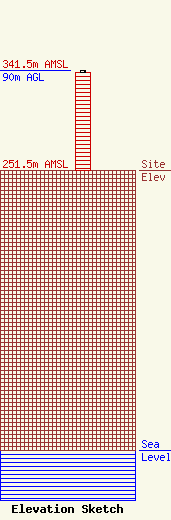
Site Elevation: 251.5 meters (825 ft) |
| Height of Structure: 88 meters (289 feet) |
| Overall Height Above Ground: 90 meters (295 feet) |
| Overall Height Above Mean Sea Level: 341.5 meters (1120 feet) |
| Owner Info | Tribune Broadcasting Company II, LLC
303 E. Wacker Drive
Chicago, IL 60601
(312) 222-3894
jasroberts@nexstar.tv |
| Contact Info | Tribune Broadcasting Company II, LLC
303 E. Wacker Drive
Chicago, IL 60601
Jason Roberts
(312) 222-3894
jasroberts@nexstar.tv |
