|
|
Antenna Structure Registration 1002038 |
 |
Registration Info | Registration Number: 1002038 |
| File Number: A0786679 |
| Status: Constructed |
| Date Constructed: 01/01/1948 |
| FAA EMI: N |
| NEPA: N |
Structure Info
| Structure Type: BPOLE |
| Structure Coordinates: 42-22-9.0 N 83-4-38.0 W (NAD 83) |
| Structure Coordinates: 42-22-08.9 N 83-04-38.3 W (Converted to NAD 27) |
| Structure Address: Fisher Building W Grand St & 2nd Ave |
| Structure City: Detroit, MI |
| Structure County: Wayne County |
| Painting & Lighting Info |
FCC Paragraph(s): 1, 3 |
| Elevation Info |
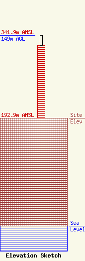
Site Elevation: 192.9 meters (633 ft) |
| Height of Structure: 130.5 meters (428 feet) |
| Overall Height Above Ground: 149 meters (489 feet) |
| Overall Height Above Mean Sea Level: 341.9 meters (1122 feet) |
| Owner Info | Radio License Holding I, LLC
3280 Peachtree Road, NW
Atlanta, GA 30305
(404) 949-0700
gary.kline@cumulus.com |
| Info |
