|
|
Antenna Structure Registration 1002155 |
 |
Registration Info | Registration Number: 1002155 |
| File Number: A1235106 |
| FAA Study: 2018-AAL-68-OE |
| FAA Issue Date: 04/09/2018 |
| Status: Constructed |
| Date Constructed: 08/20/1974 |
| NEPA: N |
Structure Info
| Structure Type: LTOWER |
| Structure Coordinates: 60-30-52.5 N 151-11-32.4 W (NAD 83) |
| Structure Coordinates: 60-30-54.6 N 151-11-24.4 W (Converted to NAD 27) |
| Structure Address: Mile 16.5 Kalifornski Beach Rd |
| Structure City: Soldotna, AK |
| Structure County: Kenai Peninsula Borough |
| Painting & Lighting Info |
FAA Chapters: NONE |
| Elevation Info |
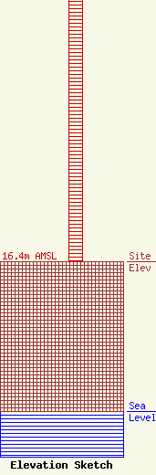
Site Elevation: 16.4 meters (54 ft) |
| Height of Structure: 36.5 meters (120 feet) |
| Overall Height Above Ground: 39 meters (128 feet) |
| Overall Height Above Mean Sea Level: 55.4 meters (182 feet) |
| Owner Info | KSRM Radio Group, Inc.
40960 Kalifornsky Beach Rd
Kenai, AK 99611
(907) 283-8700
mattwilson@radiokenai.com |
| Contact Info | KSRM Radio Group, Inc.
40960 Kalifornsky Beach Rd
Kenai, AK 99611
Matt Wilson
(907) 283-8700
mattwilson@radiokenai.com |
