|
|
Antenna Structure Registration 1002163 |
 |
Registration Info | Registration Number: 1002163 |
| File Number: A1050699 |
| FAA Study: 2014-AGL-9935-OE |
| FAA Issue Date: 09/19/2014 |
| Status: Constructed |
| Date Constructed: 09/30/2010 |
| NEPA: N |
Structure Info
| Structure Type: GTOWER |
| Structure Coordinates: 45-8-17.1 N 84-9-43.0 W (NAD 83) |
| Structure Coordinates: 45-08-17.1 N 84-09-43.0 W (Converted to NAD 27) |
| Structure Address: 0.82 Miles East Of M-33 On Tower Rd. |
| Structure City: Atlanta, MI |
| Structure County: Montmorency County |
| Painting & Lighting Info |
FAA Circular #: 70/7460-1K |
FAA Chapters: 4, 7, 12 |
Remarks: PRIOR STUDY 2010-AGL-2888-OE. FAA Chapters 4,7,12 with special condition "FAA approves the reduction of the number of white intensity obstruction lights from nine to three." |
| Elevation Info |
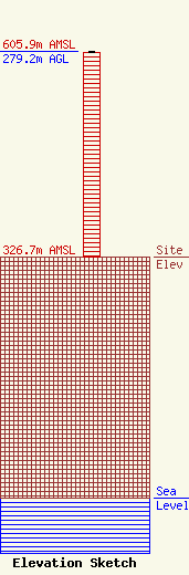
Site Elevation: 326.7 meters (1072 ft) |
| Height of Structure: 277.7 meters (911 feet) |
| Overall Height Above Ground: 279.2 meters (916 feet) |
| Overall Height Above Mean Sea Level: 605.9 meters (1988 feet) |
| Owner Info | CMU Public Broadcasting
1999 East Campus Drive
Mt. Pleasant, MI 48859
(989) 774-3105
wayne.h@cmich.edu |
| Contact Info | CMU Public Broadcasting
1999 East Campus Drive
Mt. Pleasant, MI 48859
(989) 774-3105
wayne.h@cmich.edu |
