|
|
Antenna Structure Registration 1002165 |
 |
Registration Info | Registration Number: 1002165 |
| File Number: A1050700 |
| FAA Study: 2007-AGL-7003-OE |
| FAA Issue Date: 02/26/2009 |
| Status: Constructed |
| Date Constructed: 04/16/2010 |
| FAA EMI: N |
| NEPA: N |
Structure Info
| Structure Type: TOWER |
| Structure Coordinates: 43-34-33.0 N 84-46-29.0 W (NAD 83) |
| Structure Coordinates: 43-34-32.9 N 84-46-28.9 W (Converted to NAD 27) |
| Structure Address: 64 Km W Of Blue Grass Rd Old Us Rt 27 |
| Structure City: Mount Pleasant, MI |
| Structure County: Isabella County |
| Painting & Lighting Info |
FAA Circular #: 70/7460-1G |
FAA Chapters: 3, 4, 5, 9 |
Remarks: OM&L to remain the same as prior study = PAINT/RED LIGHTS |
Remarks: PRIOR STUDY 1991-AGL-579-OE |
Remarks: Removed expiration date from determination. Scenario 1./jjs/case#635066 |
Remarks: OM&L to remain the same as prior study = PAINT/RED LIGHTS |
Remarks: PRIOR STUDY 1991-AGL-579-OE |
Remarks: Removed expiration date from determination. Scenario 1./jjs/case#635066 |
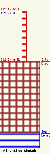
| Elevation Info |
Site Elevation: 242.9 meters (797 ft) |
| Height of Structure: 168.2 meters (552 feet) |
| Overall Height Above Ground: 169.2 meters (555 feet) |
| Overall Height Above Mean Sea Level: 412.1 meters (1352 feet) |
| Owner Info | CMU Public Broadcasting
1999 East Campus Drive
Mt. Pleasant, MI 48859
(989) 774-3105
wayne.h@cmich.edu |
| Contact Info | CMU Public Broadcasting
1999 East Campus Drive
Mt. Pleasant, MI 48859
(989) 774-3105
wayne.h@cmich.edu |
