|
|
Antenna Structure Registration 1002564 |
 |
Registration Info | Registration Number: 1002564 |
| File Number: A1342262 |
| FAA Study: 2016-AGL-378-OE |
| FAA Issue Date: 02/22/2016 |
| Status: Constructed |
| Date Constructed: 01/01/1982 |
| NEPA: N |
Structure Info
| Structure Type: LTOWER |
| Structure Coordinates: 42-21-20.0 N 85-20-28.0 W (NAD 83) |
| Structure Coordinates: 42-21-19.9 N 85-20-28.0 W (Converted to NAD 27) |
| Structure Address: 14800 East Ef Ave |
| Structure City: Augusta, MI |
| Structure County: Kalamazoo County |
| Painting & Lighting Info |
FAA Circular #: 70/7460-1L |
FAA Chapters: 4, 8, 12 |
Remarks: PRIOR STUDY 1996-AGL-3866-OE |
| Elevation Info |
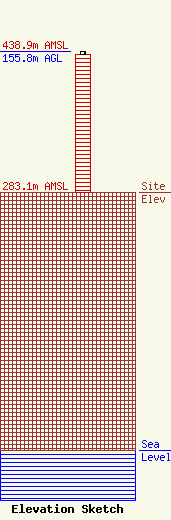
Site Elevation: 283.1 meters (929 ft) |
| Height of Structure: 151.8 meters (498 feet) |
| Overall Height Above Ground: 155.8 meters (511 feet) |
| Overall Height Above Mean Sea Level: 438.9 meters (1440 feet) |
| Owner Info | VB-S1 Assets, LLC
22 W Atlantic Avenue
Delray Beach, FL 33444
(561) 406-4015
fcc-faa@verticalbridge.com |
| Contact Info | VB-S1 Assets, LLC
22 W Atlantic Avenue
Delray Beach, FL 33444
Richard Hickey
(561) 406-4015
fcc-faa@verticalbridge.com |
