|
|
Antenna Structure Registration 1002870 |
 |
Registration Info | Registration Number: 1002870 |
| File Number: A0651106 |
| FAA Study: 2008-ASO-4077-OE |
| FAA Issue Date: 08/11/2008 |
| Status: Constructed |
| Date Constructed: 09/01/2008 |
| FAA EMI: N |
| NEPA: N |
Structure Info
| Structure Type: TOWER |
| Structure Coordinates: 35-26-27.0 N 79-12-52.0 W (NAD 83) |
| Structure Coordinates: 35-26-26.4 N 79-12-52.9 W (Converted to NAD 27) |
| Structure Address: 2201 Jefferson Davis Hwy |
| Structure City: Sanford, NC |
| Structure County: Lee County |
| Painting & Lighting Info |
FCC Paragraph(s): 1, 3, 11, 21 |
Remarks: Continue As Is OM&L = PAINT/RED LIGHTS |
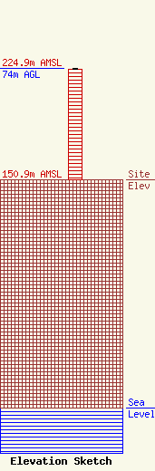
| Elevation Info |
Site Elevation: 150.9 meters (495 ft) |
| Height of Structure: 73.2 meters (240 feet) |
| Overall Height Above Ground: 74 meters (243 feet) |
| Overall Height Above Mean Sea Level: 224.9 meters (738 feet) |
| Owner Info | WWGP BROADCASTING CORPORATION DBA = WFJA
2201 JEFF DAVIS HWY
3457
SANFORD, NC 27330
(919) 775-3525
|
| Contact Info | Graham Brock, Inc.
24466
St. Simons Island, GA 31522-7466
Marilyn Matheny
(912) 638-8028
marilyn@grahambrock.com |
