|
|
Antenna Structure Registration 1003465 |
 |
Registration Info | Registration Number: 1003465 |
| File Number: A1195547 |
| FAA Study: 2020-AGL-11193-OE |
| FAA Issue Date: 05/20/2020 |
| Status: Constructed |
| Date Constructed: 10/08/2020 |
| NEPA: N |
Structure Info
| Structure Type: GTOWER |
| Structure Coordinates: 41-54-12.4 N 83-59-13.4 W (NAD 83) |
| Structure Coordinates: 41-54-12.2 N 83-59-13.6 W (Converted to NAD 27) |
| Structure Address: 1 Mi E |
| Structure City: Adrian, MI |
| Structure County: Lenawee County |
| Painting & Lighting Info |
FAA Circular #: 70/7460-1L |
FAA Chapters: 4, 8, 12 |
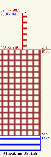
| Elevation Info |
Site Elevation: 228.6 meters (750 ft) |
| Height of Structure: 97.8 meters (321 feet) |
| Overall Height Above Ground: 98.8 meters (324 feet) |
| Overall Height Above Mean Sea Level: 327.4 meters (1074 feet) |
| Owner Info | LENAWEE BROADCASTING COMPANY DBA WLEN
687
ADRIAN, MI 49221
(517) 263-1039
juliek@wlen.com |
| Contact Info | Skywaves Consulting LLC
4
Millbury, MA 01527
David Doherty
(401) 354-2400
dave@skywaves.com |
