|
|
Antenna Structure Registration 1003548 |
 |
Registration Info | Registration Number: 1003548 |
| File Number: A0909217 |
| FAA Study: 2011-AGL-4865-OE |
| FAA Issue Date: 11/28/2011 |
| Status: Constructed |
| Date Constructed: 01/01/1979 |
| FAA EMI: N |
| NEPA: N |
Structure Info
| Structure Type: TOWER |
| Structure Coordinates: 42-3-27.2 N 84-59-53.1 W (NAD 83) |
| Structure Coordinates: 42-03-27.0 N 84-59-53.2 W (Converted to NAD 27) |
| Structure Address: Herricksville Rd .34 Km E Of Old Us 27 |
| Structure City: Girard, MI |
| Structure County: Branch County |
| Painting & Lighting Info |
FCC Paragraph(s): A2, H, 3, 4, 13, 21, 23 |
Remarks: PRIOR STUDY 1978-AGL-1568-OE |
Remarks: Continue As Is OM&L = A MED-DUAL SYSTEM |
Remarks: PRIOR STUDY 1978-AGL-1568-OE |
Remarks: Continue As Is OM&L = A MED-DUAL SYSTEM |
| Elevation Info |
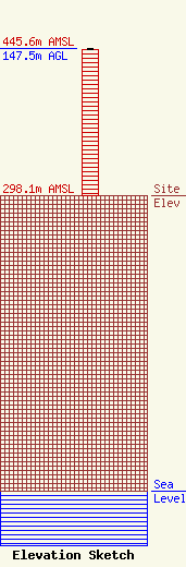
Site Elevation: 298.1 meters (978 ft) |
| Height of Structure: 146.6 meters (481 feet) |
| Overall Height Above Ground: 147.5 meters (484 feet) |
| Overall Height Above Mean Sea Level: 445.6 meters (1462 feet) |
| Owner Info | Midwest Communications, Inc.
904 Grand Avenue
Wausau, WI 54403
(715) 842-1437
paul.rahmlow@mwcradio.com |
| Contact Info | Midwest Communications, Inc.
904 Grand Avenue
Wausau, WI 54403
Paul Rahmlow
(715) 842-1437
paul.rahmlow@mwcradio.com |
