|
|
Antenna Structure Registration 1004352 |
 |
Registration Info | Registration Number: 1004352 |
| File Number: A0508277 |
| FAA Study: 00-ACE-1242-OE |
| FAA Issue Date: 07/28/2000 |
| Status: Dismantled |
| Date Constructed: 01/03/1997 |
| FAA EMI: N |
| NEPA: N |
Structure Info
| Structure Type: TOWER |
| Structure Coordinates: 37-18-36.1 N 89-31-57.8 W (NAD 83) |
| Structure Coordinates: 37-18-35.9 N 89-31-57.5 W (Converted to NAD 27) |
| Structure Address: 338 N Henderson |
| Structure City: Cape Girardeau, MO |
| Structure County: Cape Girardeau County |
| Painting & Lighting Info |
FCC Paragraph(s): A1, H, 3, 11, 21, 23 |
Remarks: CONTINUE OM&L MED DUAL SYSTEM |
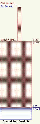
| Elevation Info |
Site Elevation: 138.1 meters (453 ft) |
| Height of Structure: 71 meters (233 feet) |
| Overall Height Above Ground: 76.8 meters (252 feet) |
| Overall Height Above Mean Sea Level: 214.9 meters (705 feet) |
| Owner Info | SOUTHEAST MISSOURI STATE UNIVERSITY
1 UNIVERSITY PLZ MS 0300
CAPE GIRARDEAU, MO 63701
(573) 651-5070
djwoods@semo.edu |
| Contact Info | KRCU-FM
One University Plaza, MS 0300
Cape Girardeau, MO 63701
Danny Woods
(573) 651-5070
djwoods@semo.edu |
