|
|
Antenna Structure Registration 1004666 |
 |
Registration Info | Registration Number: 1004666 |
| File Number: A1288924 |
| FAA Study: 2024-ACE-2447-OE |
| FAA Issue Date: 05/10/2024 |
| Status: Constructed |
| Date Constructed: 08/15/1995 |
| NEPA: N |
Structure Info
| Structure Type: GTOWER |
| Structure Coordinates: 37-59-26.0 N 91-43-58.5 W (NAD 83) |
| Structure Coordinates: 37-59-25.8 N 91-43-57.9 W (Converted to NAD 27) |
| Structure Address: Hwy V |
| Structure City: Rolla, MO |
| Structure County: Phelps County |
| Painting & Lighting Info |
FAA Circular #: 70/7460-1M |
FAA Chapters: 4, 8, 15 |
Remarks: PRIOR STUDY 2022-ACE-6881-OE |
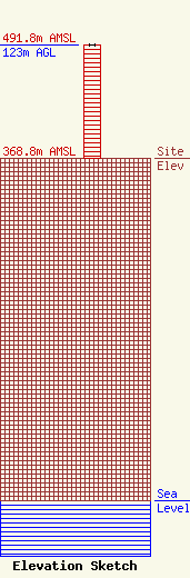
| Elevation Info |
Site Elevation: 368.8 meters (1210 ft) |
| Height of Structure: 123 meters (404 feet) |
| Overall Height Above Ground: 123 meters (404 feet) |
| Overall Height Above Mean Sea Level: 491.8 meters (1614 feet) |
| Owner Info | MISSOURI RSA 11/12 TOWER HOLDINGS LLC
50 Royal Little Dr
Providence, RI 02904
(855) 699-7073
ATTNRC@att.com |
| Contact Info | MISSOURI RSA 11/12 TOWER HOLDINGS LLC
50 Royal Little Dr
Providence, RI 02904
Jessica Dunk
(855) 699-7073
ATTNRC@att.com |
