|
|
Antenna Structure Registration 1005124 |
 |
Registration Info | Registration Number: 1005124 |
| File Number: A1063872 |
| FAA Study: 2013-ANE-382-OE |
| FAA Issue Date: 03/06/2013 |
| Status: Constructed |
| Date Constructed: 04/01/2013 |
| FAA EMI: N |
| NEPA: N |
Structure Info
| Structure Type: LTOWER |
| Structure Coordinates: 41-51-55.9 N 71-17-15.4 W (NAD 83) |
| Structure Coordinates: 41-51-55.5 N 71-17-17.2 W (Converted to NAD 27) |
| Structure Address: 89 Pine St |
| Structure City: Rehoboth, MA |
| Structure County: Bristol County |
| Painting & Lighting Info |
FAA Chapters: NONE |
Remarks: PRIOR STUDY 2013-ANE-49-OE |
| Elevation Info |
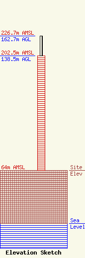
Site Elevation: 64 meters (210 ft) |
| Height of Structure: 138.5 meters (454 feet) |
| Overall Height Above Ground: 162.7 meters (534 feet) |
| Overall Height Above Mean Sea Level: 226.7 meters (744 feet) |
| Owner Info | WJAR Licensee, LLC
Pillsbury Winthrop Shaw Pittman LLP
Washington, DC 20036
(202) 663-8195
miles.mason@pillsburylaw.com |
| Contact Info | WJAR Licensee, LLC
Pillsbury Winthrop Shaw Pittman LLP
Washington, DC 20036
(202) 663-8195
miles.mason@pillsburylaw.com |
