|
|
Antenna Structure Registration 1005294 |
 |
Registration Info | Registration Number: 1005294 |
| File Number: A0755318 |
| Status: Constructed |
| Date Constructed: 10/29/1990 |
| FAA EMI: N |
| NEPA: N |
Structure Info
| Structure Type: TOWER |
| Structure Coordinates: 36-33-34.0 N 80-49-24.0 W (NAD 83) |
| Structure Coordinates: 36-33-33.5 N 80-49-24.7 W (Converted to NAD 27) |
| Structure Address: Fisher Peak Surry Cty 5.2 Km E |
| Structure City: Lowgap, NC |
| Structure County: Surry County |
| Painting & Lighting Info |
FCC Paragraph(s): 1, 3, 11, 21 |
| Elevation Info |
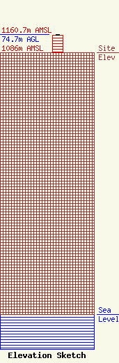
Site Elevation: 1086 meters (3563 ft) |
| Height of Structure: 73 meters (240 feet) |
| Overall Height Above Ground: 74.7 meters (245 feet) |
| Overall Height Above Mean Sea Level: 1160.7 meters (3808 feet) |
| Owner Info | BLUE RIDGE RADIO INC
104 Pine Cone Pointe
Galax, VA 24333
(910) 786-4498
|
