|
|
Antenna Structure Registration 1005666 |
 |
Registration Info | Registration Number: 1005666 |
| File Number: A1290913 |
| FAA Study: 94-AWP-1735-OE |
| FAA Issue Date: 01/06/1995 |
| Status: Constructed |
| Date Constructed: 11/01/1995 |
| NEPA: N |
Structure Info
|
| Structure Coordinates: 34-41-12.0 N 112-7-2.0 W (NAD 83) |
| Structure Coordinates: 34-41-11.9 N 112-06-59.4 W (Converted to NAD 27) |
| Structure Address: Mingus Mountain South Antenna Tower Site |
| Structure City: Yavapai County, AZ |
| Structure County: Yavapai County |
| Painting & Lighting Info |
FAA Chapters: NONE |
| Elevation Info |
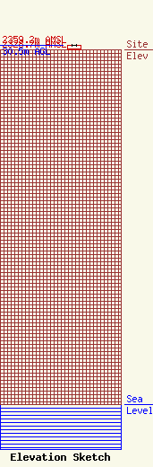
Site Elevation: 2328.7 meters (7640 ft) |
| Height of Structure: 30.5 meters (100 feet) |
| Overall Height Above Ground: 30.5 meters (100 feet) |
| Overall Height Above Mean Sea Level: 2359.2 meters (7740 feet) |
| Owner Info | VB-S1 Assets, LLC
750 Park of Commerce Drive
Boca Raton, FL 33487
(561) 406-4023
fcc-faa@verticalbridge.com |
| Contact Info | VB-S1 Assets, LLC
750 Park of Commerce Drive
Boca Raton, FL 33487
Matthew Bonfante
(561) 406-4023
fcc-faa@verticalbridge.com |
