|
|
Antenna Structure Registration 1005701 |
 |
Registration Info | Registration Number: 1005701 |
| File Number: A1351102 |
| Status: Constructed |
| Date Constructed: 06/01/1983 |
| FAA EMI: N |
| NEPA: N |
Structure Info
| Structure Type: TOWER |
| Structure Coordinates: 34-12-20.0 N 109-56-28.0 W (NAD 83) |
| Structure Coordinates: 34-12-19.8 N 109-56-25.6 W (Converted to NAD 27) |
| Structure Address: Porter Mountain Us Forest Svc 5 Mi Se |
| Structure City: Show Low, AZ |
| Structure County: Navajo County |
| Painting & Lighting Info |
FCC Paragraph(s): 1, 3, 11, 21 |
| Elevation Info |
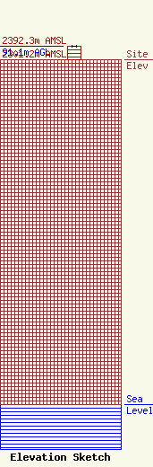
Site Elevation: 2301.2 meters (7550 ft) |
| Height of Structure: 90.2 meters (296 feet) |
| Overall Height Above Ground: 91.1 meters (299 feet) |
| Overall Height Above Mean Sea Level: 2392.3 meters (7849 feet) |
| Owner Info | Vertical Bridge S3 Assets, LLC
22 W Atlantic Avenue
Delray Beach, FL 33444
(561) 406-4015
fcc-faa@verticalbridge.com |
| Contact Info | Vertical Bridge S3 Assets, LLC
22 W Atlantic Avenue
Delray Beach, FL 33444
Richard Hickey
(561) 406-4015
fcc-faa@verticalbridge.com |
