|
|
Antenna Structure Registration 1005726 |
 |
Registration Info | Registration Number: 1005726 |
| File Number: A1219991 |
| Status: Dismantled |
| Date Constructed: 08/01/1947 |
| FAA EMI: N |
| NEPA: N |
Structure Info
|
| Structure Coordinates: 43-8-3.0 N 86-15-37.0 W (NAD 83) |
| Structure Coordinates: 43-08-02.9 N 86-15-36.8 W (Converted to NAD 27) |
| Structure Address: 592 W Pontaluna |
| Structure City: Muskegon, MI |
| Structure County: Muskegon County |
| Painting & Lighting Info |
FCC Paragraph(s): 1, 3, 12, 21 |
| Elevation Info |
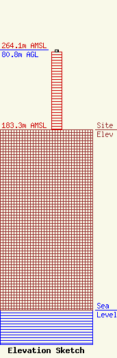
Site Elevation: 183.3 meters (601 ft) |
| Height of Structure: 78.8 meters (259 feet) |
| Overall Height Above Ground: 80.8 meters (265 feet) |
| Overall Height Above Mean Sea Level: 264.1 meters (866 feet) |
| Owner Info | Grand Valley State University
301 West Fulton
Grand Rapids, MI 49504-6492
(616) 331-6666
walentam@gvsu.edu |
