|
|
Antenna Structure Registration 1005873 |
 |
Registration Info | Registration Number: 1005873 |
| File Number: A1379254 |
| FAA Study: 2025-AGL-15643-OE |
| FAA Issue Date: 01/07/2026 |
| Status: Granted |
| Date Constructed: 01/01/1969 |
| NEPA: N |
Structure Info
| Structure Type: GTOWER |
| Structure Coordinates: 43-28-36.5 N 83-57-5.8 W (NAD 83) |
| Structure Coordinates: 43-28-36.4 N 83-57-05.9 W (Converted to NAD 27) |
| Structure Address: 1795 Tittabawassee Rd |
| Structure City: Saginaw, MI |
| Structure County: Saginaw County |
| Painting & Lighting Info |
FCC Paragraph(s): 1, 3, 12, 21 |
Remarks: Continue As Is OM&L = PAINT/RED LIGHTS |
Remarks: PRIOR STUDY 2024-AGL-17258-OE |
Remarks: Continue As Is OM&L = PAINT/RED LIGHTS |
Remarks: PRIOR STUDY 2024-AGL-17258-OE |
| Elevation Info |
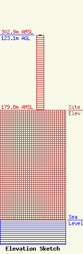
Site Elevation: 179.8 meters (590 ft) |
| Height of Structure: 121.9 meters (400 feet) |
| Overall Height Above Ground: 123.1 meters (404 feet) |
| Overall Height Above Mean Sea Level: 302.9 meters (994 feet) |
| Owner Info | Vertical Bridge S3 Assets, LLC
22 W Atlantic Avenue
Delray Beach, FL 33444
(561) 406-4015
fcc-faa@verticalbridge.com |
| Contact Info | Vertical Bridge S3 Assets, LLC
22 W Atlantic Avenue
Delray Beach, FL 33444
Richard Hickey
(561) 406-4015
fcc-faa@verticalbridge.com |
