|
|
Antenna Structure Registration 1006000 |
 |
Registration Info | Registration Number: 1006000 |
| File Number: A1150409 |
| FAA Study: 2000-ANE-973-OE |
| FAA Issue Date: 02/20/2001 |
| Status: Constructed |
| Date Constructed: 01/01/1985 |
| FAA EMI: Y |
| NEPA: N |
Structure Info
| Structure Type: BTWR |
| Structure Coordinates: 42-15-45.6 N 71-47-57.8 W (NAD 83) |
| Structure Coordinates: 42-15-45.3 N 71-47-59.5 W (Converted to NAD 27) |
| Structure Address: Bank Of Boston/ Worcester Tower |
| Structure City: Worcester, MA |
| Structure County: Worcester County |
| Painting & Lighting Info |
FAA Circular #: 70/7460-1K |
FAA Chapters: 4, 5, 12 |
Remarks: PRIOR STUDY 95-ANE-0391-OE |
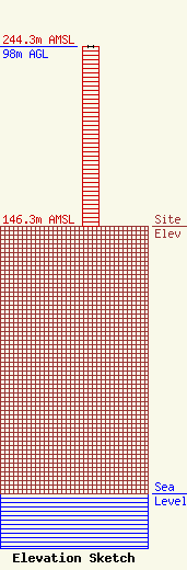
| Elevation Info |
Site Elevation: 146.3 meters (480 ft) |
| Height of Structure: 98 meters (322 feet) |
| Overall Height Above Ground: 98 meters (322 feet) |
| Overall Height Above Mean Sea Level: 244.3 meters (802 feet) |
| Owner Info | Cumulus Radio, LLC
3280 Peachtree Rd, Suite 2200
Atlanta, GA 30305
(404) 949-0700
towermanagement@cumulus.com |
| Contact Info | Cumulus Radio, LLC
2300 Vartan Way, Suite 130
Harrisburg, PA 17110
(717) 901-0720
dave.supplee@cumulus.com |
