|
|
Antenna Structure Registration 1006277 |
 |
Registration Info | Registration Number: 1006277 |
| File Number: A1055762 |
| FAA Study: 98-AEA-3234-OE |
| FAA Issue Date: 12/01/1998 |
| Status: Constructed |
| Date Constructed: 03/08/1996 |
| FAA EMI: N |
| NEPA: N |
Structure Info
| Structure Type: MAST |
| Structure Coordinates: 42-1-56.1 N 76-47-1.0 W (NAD 83) |
| Structure Coordinates: 42-01-55.8 N 76-47-02.2 W (Converted to NAD 27) |
| Structure Address: Comfort Hill Road |
| Structure City: Ashland, NY |
| Structure County: Chemung County |
| Painting & Lighting Info |
FAA Chapters: NONE |
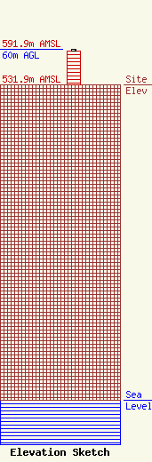
| Elevation Info |
Site Elevation: 531.9 meters (1745 ft) |
| Height of Structure: 56.4 meters (185 feet) |
| Overall Height Above Ground: 60 meters (197 feet) |
| Overall Height Above Mean Sea Level: 591.9 meters (1942 feet) |
| Owner Info | BELL ATLANTIC MOBILE SYSTEMS OF ALLENTOWN, INC
5055 North Point Pkwy
Alpharetta, GA 30022
(770) 797-1070
NetworkRegulatory@VerizonWireless.com |
| Contact Info | BELL ATLANTIC MOBILE SYSTEMS OF ALLENTOWN, INC
5055 North Point Pkwy
Alpharetta, GA 30022
Regulatory Manager
(770) 797-1070
NetworkRegulatory@VerizonWireless.com |
