|
|
Antenna Structure Registration 1006470 |
 |
Registration Info | Registration Number: 1006470 |
| File Number: A1338182 |
| FAA Study: 2011-AGL-2668-OE |
| FAA Issue Date: 05/20/2011 |
| Status: Constructed |
| Date Constructed: 05/20/2011 |
| FAA EMI: N |
| NEPA: N |
Structure Info
| Structure Type: TOWER |
| Structure Coordinates: 41-49-54.6 N 86-15-20.2 W (NAD 83) |
| Structure Coordinates: 41-49-54.4 N 86-15-20.2 W (Converted to NAD 27) |
| Structure Address: 317 N 3rd St |
| Structure City: Niles, MI |
| Structure County: Berrien County |
| Painting & Lighting Info |
FAA Chapters: NONE |
Remarks: PRIOR STUDY 1981-AGL-944-OE |
| Elevation Info |
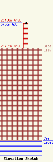
Site Elevation: 207.2 meters (680 ft) |
| Height of Structure: 54.8 meters (180 feet) |
| Overall Height Above Ground: 57.6 meters (189 feet) |
| Overall Height Above Mean Sea Level: 264.8 meters (869 feet) |
| Owner Info | Michigan Bell
3400 W Plano Pkwy
Plano, TX 75075
(855) 699-7073
ATTNRC@att.com |
| Contact Info | AT&T Mobility Services LLC
3400 W Plano Pkwy
Plano, TX 75075
Jaime Ochoa
(855) 699-7073
ATTNRC@att.com |
