|
|
Antenna Structure Registration 1006744 |
 |
Registration Info | Registration Number: 1006744 |
| File Number: A0981989 |
| FAA Study: 74-EA-868-OE |
| FAA Issue Date: 09/09/1974 |
| Status: Constructed |
| Date Constructed: 01/01/1974 |
| FAA EMI: N |
| NEPA: N |
Structure Info
|
| Structure Coordinates: 44-34-43.0 N 75-30-50.0 W (NAD 83) |
| Structure Coordinates: 44-34-42.8 N 75-30-51.2 W (Converted to NAD 27) |
| Structure Address: Black Lake Rd .4 Km S Of Galilee |
| Structure City: Oswegatchie, NY |
| Structure County: St. Lawrence County |
| Painting & Lighting Info |
FCC Paragraph(s): 1, 3, 12, 21 |
Remarks: RED LIGHTS/PAINT |
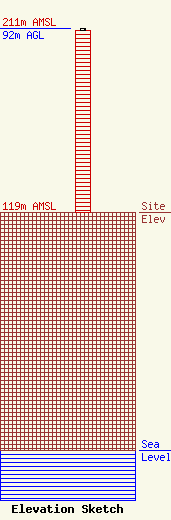
| Elevation Info |
Site Elevation: 119 meters (390 ft) |
| Height of Structure: 91 meters (299 feet) |
| Overall Height Above Ground: 92 meters (302 feet) |
| Overall Height Above Mean Sea Level: 211 meters (692 feet) |
| Owner Info | Stephens Media Group - Ogdensburg, LLC
2448 E. 81st Street
Tulsa, OK 74137
(918) 492-2660
deborah.cox@smgok.com |
| Contact Info | Stephens Media Group - Ogdensburg, LLC
2448 E. 81st Street
Tulsa, OK 74137
Deborah Cox
(918) 492-2660
deborah.cox@smgok.com |
