|
|
Antenna Structure Registration 1006963 |
 |
Registration Info | Registration Number: 1006963 |
| File Number: A1342286 |
| Status: Constructed |
| Date Constructed: 01/01/1986 |
| FAA EMI: N |
| NEPA: N |
Structure Info
| Structure Type: TOWER |
| Structure Coordinates: 43-8-39.0 N 75-10-44.0 W (NAD 83) |
| Structure Coordinates: 43-08-38.7 N 75-10-45.4 W (Converted to NAD 27) |
| Structure Address: Smith Hill |
| Structure City: Utica, NY |
| Structure County: Oneida County |
| Painting & Lighting Info |
FCC Paragraph(s): 1, 3, 11, 21 |
| Elevation Info |
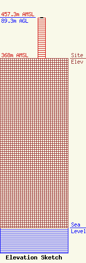
Site Elevation: 368 meters (1207 ft) |
| Height of Structure: 88.3 meters (290 feet) |
| Overall Height Above Ground: 89.3 meters (293 feet) |
| Overall Height Above Mean Sea Level: 457.3 meters (1500 feet) |
| Owner Info | VB-S1 Assets, LLC
22 W Atlantic Avenue
Delray Beach, FL 33444
(561) 406-4015
fcc-faa@verticalbridge.com |
| Contact Info | VB-S1 Assets, LLC
22 W Atlantic Avenue
Delray Beach, FL 33444
Richard Hickey
(561) 406-4015
fcc-faa@verticalbridge.com |
