|
|
Antenna Structure Registration 1007105 |
 |
Registration Info | Registration Number: 1007105 |
| File Number: A1095455 |
| FAA Study: 2017-AEA-4816-OE |
| FAA Issue Date: 05/17/2017 |
| Status: Constructed |
| Date Constructed: 06/01/1964 |
| NEPA: N |
Structure Info
| Structure Type: 4GTA2 |
| Structure Coordinates: 42-52-58.4 N 78-37-53.6 W (NAD 83) |
| Structure Coordinates: 42-52-58.2 N 78-37-54.5 W (Converted to NAD 27) |
| Structure Address: Northwest Tower (d2/n2); 5429 William Street |
| Structure City: Lancaster, NY |
| Structure County: Erie County |
| Painting & Lighting Info |
FAA Chapters: NONE |
Remarks: PRIOR STUDY 1996-AEA-748-OE |
| Elevation Info |
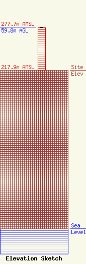
Site Elevation: 217.9 meters (715 ft) |
| Height of Structure: 58.8 meters (193 feet) |
| Overall Height Above Ground: 59.8 meters (196 feet) |
| Overall Height Above Mean Sea Level: 277.7 meters (911 feet) |
| Owner Info | Dome Broadcasting, Inc.
5426 William Street
170
Lancaster, NY 14086-0170
(716) 681-1313
louschriver@aol.com |
| Contact Info | Dome Broadcasting, Inc.
5426 William Street
170
Lancaster, NY 14086-0170
Louis Schriver
(716) 681-1313
louschriver@aol.com |
