|
|
Antenna Structure Registration 1007418 |
 |
Registration Info | Registration Number: 1007418 |
| File Number: A0008824 |
| FAA Study: 84-AAL-129-OE |
| FAA Issue Date: 08/26/1985 |
| Status: Constructed |
| Date Constructed: 07/07/1986 |
| NEPA: N |
Structure Info
| Structure Type: TOWER |
| Structure Coordinates: 61-25-20.0 N 149-52-28.0 W (NAD 83) |
| Structure Coordinates: 61-25-22.0 N 149-52-20.0 W (Converted to NAD 27) |
| Structure Address: Mile 2.0 Point Mac Kenzie Rd |
| Structure City: Kink, AK |
| Structure County: Matanuska-Susitna Borough |
| Painting & Lighting Info |
FAA Circular #: 70/7460-1G |
FAA Chapters: 4, 6, 9 |
Remarks: HIGH INTENSITY WHITE LIGHTS. |
| Elevation Info |
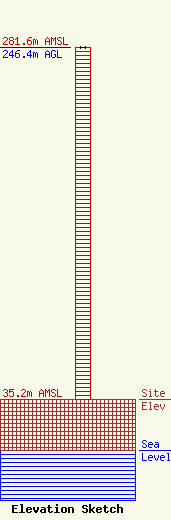
Site Elevation: 35.2 meters (115 ft) |
| Height of Structure: 246.4 meters (808 feet) |
| Overall Height Above Ground: 246.4 meters (808 feet) |
| Overall Height Above Mean Sea Level: 281.6 meters (924 feet) |
| Owner Info | ALASKA PUBLIC TELECOMMUNICATIONS INC
3877 UNIVERSITY DR
ANCHORAGE, AK 99508
(907) 563-7070
FRANK@KAKM.PBS.ORG |
