|
|
Antenna Structure Registration 1007580 |
 |
Registration Info | Registration Number: 1007580 |
| File Number: A1087668 |
| FAA Study: 2013-ASO-966-OE |
| FAA Issue Date: 02/26/2013 |
| Status: Constructed |
| Date Constructed: 01/01/1982 |
| FAA EMI: N |
| NEPA: N |
Structure Info
| Structure Type: GTOWER |
| Structure Coordinates: 36-20-42.0 N 79-54-23.2 W (NAD 83) |
| Structure Coordinates: 36-20-41.5 N 79-54-24.1 W (Converted to NAD 27) |
| Structure Address: 500 Lowe Rd |
| Structure City: Madison, NC |
| Structure County: Rockingham County |
| Painting & Lighting Info |
FAA Circular #: 70/7460-1K |
FAA Chapters: 4, 7, 12 |
Remarks: PRIOR STUDY 1984-ASO-1299-OE |
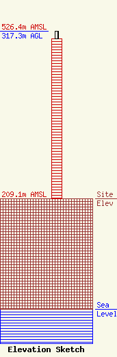
| Elevation Info |
Site Elevation: 209.1 meters (686 ft) |
| Height of Structure: 303 meters (994 feet) |
| Overall Height Above Ground: 317.3 meters (1041 feet) |
| Overall Height Above Mean Sea Level: 526.4 meters (1727 feet) |
| Owner Info | iHeartMedia Entertainment, Inc.
7136 S. Yale Avenue
TULSA, OK 74136
(918) 664-4581
fcccontact@iheartmedia.com |
| Contact Info | iHeartMedia, Inc.
7136 S. Yale Avenue
TULSA, OK 74136
(918) 664-4581
fcccontact@iheartmedia.com |
