|
|
Antenna Structure Registration 1007790 |
 |
Registration Info | Registration Number: 1007790 |
| File Number: A0355771 |
| Status: Constructed |
| Date Constructed: 01/01/1948 |
| FAA EMI: N |
| NEPA: N |
Structure Info
| Structure Type: TOWER |
| Structure Coordinates: 36-16-47.0 N 77-1-58.0 W (NAD 83) |
| Structure Coordinates: 36-16-46.4 N 77-01-59.1 W (Converted to NAD 27) |
| Structure Address: Nc Hwy 42 3 Mi W |
| Structure City: Ahoskie, NC |
| Structure County: Hertford County |
| Painting & Lighting Info |
FCC Paragraph(s): 1, 3, 12, 21 |
| Elevation Info |
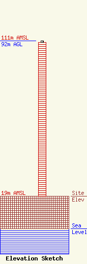
Site Elevation: 19 meters (62 ft) |
| Height of Structure: 91 meters (299 feet) |
| Overall Height Above Ground: 92 meters (302 feet) |
| Overall Height Above Mean Sea Level: 111 meters (364 feet) |
| Owner Info | WRCS AM 970, Inc. dba WRCS
443 NC Highway 42 West
Ahoskie, NC 27910
(252) 332-3101
|
| Info |
