|
|
Antenna Structure Registration 1008160 |
 |
Registration Info | Registration Number: 1008160 |
| File Number: A1278266 |
| FAA Study: 2017-AGL-9884-OE |
| FAA Issue Date: 08/10/2017 |
| Status: Constructed |
| Date Constructed: 12/01/1976 |
| NEPA: N |
Structure Info
| Structure Type: GTOWER |
| Structure Coordinates: 42-33-6.6 N 84-24-20.6 W (NAD 83) |
| Structure Coordinates: 42-33-06.5 N 84-24-20.7 W (Converted to NAD 27) |
| Structure Address: Twr 1 1517 Tomlinson Rd |
| Structure City: Mason, MI |
| Structure County: Ingham County |
| Painting & Lighting Info |
FCC Paragraph(s): 1, 3, 11, 21 |
Remarks: PRIOR STUDY 2013-AGL-7441-OE |
Remarks: Continue As Is OM&L = PAINT/RED LIGHTS |
Remarks: PRIOR STUDY 2013-AGL-7441-OE |
| Elevation Info |
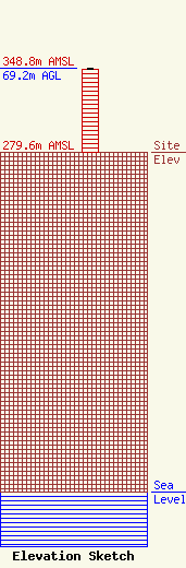
Site Elevation: 279.6 meters (917 ft) |
| Height of Structure: 68.1 meters (223 feet) |
| Overall Height Above Ground: 69.2 meters (227 feet) |
| Overall Height Above Mean Sea Level: 348.8 meters (1144 feet) |
| Owner Info | Intentional Life Media
7355 N. Oracle Road
Tucson, AZ 85704
(520) 742-6976
abiddell@flc.org |
| Contact Info | Intentional Life Media
7355 N. Oracle
Tucson, AZ 85704
Adam Biddell
(520) 219-7708
abiddell@flc.org |
