|
|
Antenna Structure Registration 1008564 |
 |
Registration Info | Registration Number: 1008564 |
| File Number: A0010197 |
| FAA Study: 83-AGL-1274-OE |
| FAA Issue Date: 08/26/1983 |
| Status: Constructed |
| Date Constructed: 01/01/1984 |
| NEPA: N |
Structure Info
| Structure Type: TOWER |
| Structure Coordinates: 42-57-13.0 N 85-41-55.0 W (NAD 83) |
| Structure Coordinates: 42-57-12.9 N 85-41-54.9 W (Converted to NAD 27) |
| Structure Address: 399 Garfield S W |
| Structure City: Grand Rapids, MI |
| Structure County: Kent County |
| Painting & Lighting Info |
FCC Paragraph(s): 1, 3, 5, 14, 21 |
Remarks: RED LIGHTS/PAINT |
| Elevation Info |
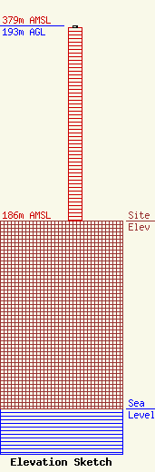
Site Elevation: 186 meters (610 ft) |
| Height of Structure: 192 meters (630 feet) |
| Overall Height Above Ground: 193 meters (633 feet) |
| Overall Height Above Mean Sea Level: 379 meters (1243 feet) |
| Owner Info | FURNITURE CITY BROADCASTING CORP DBA = WFUR FM
399 GARFIELD S W
GRAND RAPIDS, MI 49504
(616) 451-9387
|
