|
|
Antenna Structure Registration 1008922 |
 |
Registration Info | Registration Number: 1008922 |
| File Number: A1161346 |
| FAA Study: 96-AGL-4174-OE |
| Status: Constructed |
| Date Constructed: 05/01/1997 |
| FAA EMI: N |
| NEPA: N |
Structure Info
| Structure Type: TOWER |
| Structure Coordinates: 40-13-27.0 N 88-17-56.0 W (NAD 83) |
| Structure Coordinates: 40-13-26.9 N 88-17-55.8 W (Converted to NAD 27) |
| Structure Address: .2 Km W Int 2400n & 900e |
| Structure City: Champaign, IL |
| Structure County: Champaign County |
| Painting & Lighting Info |
FAA Circular #: 70/7460-1J |
FAA Chapters: 3, 4, 5, 13 |
| Elevation Info |
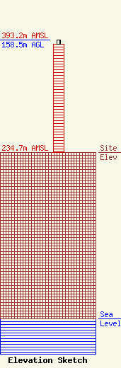
Site Elevation: 234.7 meters (770 ft) |
| Height of Structure: 152.4 meters (500 feet) |
| Overall Height Above Ground: 158.5 meters (520 feet) |
| Overall Height Above Mean Sea Level: 393.2 meters (1290 feet) |
| Owner Info | Tarpon Towers II, LLC
8916 77th Terrace East
Lakewood Ranch, FL 34202
(941) 757-5010
tbowman@tarpontowers.com |
| Contact Info | Tarpon Towers II, LLC
8916 77th Terrace East
Lakewood Ranch, FL 34202
Todd Bowman
(941) 757-5010
tbowman@tarpontowers.com |
