|
|
Antenna Structure Registration 1009115 |
 |
Registration Info | Registration Number: 1009115 |
| File Number: A1152292 |
| FAA Study: CHI-OE-66-11 |
| Status: Constructed |
| Date Constructed: 06/01/1966 |
| NEPA: N |
Structure Info
| Structure Type: 3TA1 |
| Structure Coordinates: 41-18-16.0 N 89-5-45.0 W (NAD 83) |
| Structure Coordinates: 41-18-15.9 N 89-05-44.7 W (Converted to NAD 27) |
| Structure Address: Twr 1 .6 Mi S Ill River 1.5 Mi W |
| Structure City: Oglesby, IL |
| Structure County: LaSalle County |
| Painting & Lighting Info |
FCC Paragraph(s): 1, 3, 12, 21 |
| Elevation Info |
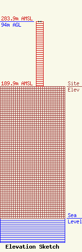
Site Elevation: 189.9 meters (623 ft) |
| Height of Structure: 94 meters (308 feet) |
| Overall Height Above Ground: 94 meters (308 feet) |
| Overall Height Above Mean Sea Level: 283.9 meters (931 feet) |
| Owner Info | Starved Rock Media, Inc.
1 Broadcast Lane
Oglesby, IL 61348
(815) 223-3100
programdirector@993wajk.com |
| Contact Info | Starved Rock Media, Inc.
1 Broadcast Lane
Oglesby, IL 61348
John Spencer
(815) 223-3100
programdirector@993wajk.com |
