|
|
Antenna Structure Registration 1009278 |
 |
Registration Info | Registration Number: 1009278 |
| File Number: A0011033 |
| Status: Constructed |
| Date Constructed: 01/01/1964 |
| NEPA: N |
Structure Info
| Structure Type: TOWER |
| Structure Coordinates: 39-42-37.0 N 90-16-3.0 W (NAD 83) |
| Structure Coordinates: 39-42-36.8 N 90-16-02.6 W (Converted to NAD 27) |
| Structure Address: Massey Rd .8 Mi S Of Us Rt 36 |
| Structure City: Jacksonville, IL |
| Structure County: Morgan County |
| Painting & Lighting Info |
FCC Paragraph(s): 1, 3, 11, 21 |
| Elevation Info |
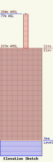
Site Elevation: 207 meters (679 ft) |
| Height of Structure: 76 meters (249 feet) |
| Overall Height Above Ground: 77 meters (253 feet) |
| Overall Height Above Mean Sea Level: 284 meters (932 feet) |
| Owner Info | ILLINOIS, STATE OF
531 SANGAMON AVE
SPRINGFIELD, IL 62702
(217) 782-7345
|
