|
|
Antenna Structure Registration 1009520 |
 |
Registration Info | Registration Number: 1009520 |
| File Number: A1342301 |
| FAA Study: 2006-AGL-5422-OE |
| FAA Issue Date: 09/06/2006 |
| Status: Constructed |
| Date Constructed: 11/01/1985 |
| FAA EMI: N |
| NEPA: N |
Structure Info
| Structure Type: 3TA2 |
| Structure Coordinates: 42-16-45.2 N 89-2-14.9 W (NAD 83) |
| Structure Coordinates: 42-16-45.1 N 89-02-14.5 W (Converted to NAD 27) |
| Structure Address: 3901 Brendenwood Rd |
| Structure City: Rockford, IL |
| Structure County: Winnebago County |
| Painting & Lighting Info |
FCC Paragraph(s): 3, 12, 21 |
Remarks: PRIOR STUDY 1983-AGL-1074-OE |
Remarks: Continue As Is OM&L = RED LIGHTS |
Remarks: PRIOR STUDY 1983-AGL-1074-OE |
Remarks: Continue As Is OM&L = RED LIGHTS |
| Elevation Info |
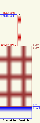
Site Elevation: 254.8 meters (836 ft) |
| Height of Structure: 132.9 meters (436 feet) |
| Overall Height Above Ground: 133.8 meters (439 feet) |
| Overall Height Above Mean Sea Level: 388.6 meters (1275 feet) |
| Owner Info | VB-S1 Assets, LLC
22 W Atlantic Avenue
Delray Beach, FL 33444
(561) 406-4015
fcc-faa@verticalbridge.com |
| Contact Info | VB-S1 Assets, LLC
22 W Atlantic Avenue
Delray Beach, FL 33444
Richard Hickey
(561) 406-4015
fcc-faa@verticalbridge.com |
