|
|
Antenna Structure Registration 1011068 |
 |
Registration Info | Registration Number: 1011068 |
| File Number: A1280332 |
| FAA Study: 2021-AGL-15578-OE |
| FAA Issue Date: 06/29/2021 |
| Status: Constructed |
| Date Constructed: 06/01/1983 |
| NEPA: N |
Structure Info
| Structure Type: GTOWER |
| Structure Coordinates: 41-6-38.3 N 83-22-9.5 W (NAD 83) |
| Structure Coordinates: 41-06-38.1 N 83-22-09.8 W (Converted to NAD 27) |
| Structure Address: 861 S State Road 587 |
| Structure City: New Riegel, OH |
| Structure County: Seneca County |
| Painting & Lighting Info |
FAA Circular #: 70/7460-1F |
FAA Chapters: 3, 4, 5, 9 |
Remarks: OM&L to remain the same as prior study = PAINT/RED LIGHTS |
Remarks: PRIOR STUDY 1982-AGL-1274-OE |
Remarks: OM&L to remain the same as prior study = PAINT/RED LIGHTS |
| Elevation Info |
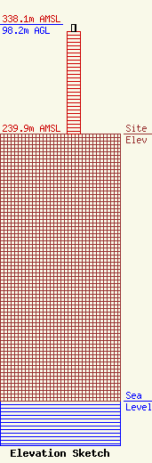
Site Elevation: 239.9 meters (787 ft) |
| Height of Structure: 92 meters (302 feet) |
| Overall Height Above Ground: 98.2 meters (322 feet) |
| Overall Height Above Mean Sea Level: 338.1 meters (1109 feet) |
| Owner Info | EIP Holdings II, LLC
2 ALLEGHENY CTR STE 1002
PITTSBURGH, PA 15212
(844) 282-7748
regulatory@everestinfrastructure.com |
| Contact Info | EIP Holdings II, LLC
2 ALLEGHENY CTR STE 1002
PITTSBURGH, PA 15212
Justin Burgess
(844) 282-7748
regulatory@everestinfrastructure.com |
