|
|
Antenna Structure Registration 1011093 |
 |
Registration Info | Registration Number: 1011093 |
| File Number: A1212580 |
| FAA Study: 2011-AWP-8073-OE |
| FAA Issue Date: 12/28/2011 |
| Status: Constructed |
| Date Constructed: 02/01/1983 |
| FAA EMI: N |
| NEPA: N |
Structure Info
| Structure Type: TOWER |
| Structure Coordinates: 39-15-25.2 N 119-42-40.0 W (NAD 83) |
| Structure Coordinates: 39-15-25.5 N 119-42-36.3 W (Converted to NAD 27) |
| Structure Address: Mc Clellan Peak |
| Structure City: Carson City, NV |
| Structure County: Storey County |
| Painting & Lighting Info |
FAA Chapters: NONE |
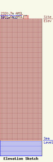
| Elevation Info |
Site Elevation: 2261.6 meters (7420 ft) |
| Height of Structure: 59.1 meters (194 feet) |
| Overall Height Above Ground: 59.1 meters (194 feet) |
| Overall Height Above Mean Sea Level: 2320.7 meters (7614 feet) |
| Owner Info | Americom Limited Partnership
961 Matley LN
Reno, NV 89502
(775) 829-1964
fccadministrator@renomediagroup.com |
| Contact Info | Americom Limited Partnership
961 Matley LN
Reno, NV 89502
Tracy White
(775) 829-1964
fccadministrator@renomediagroup.com |
