|
|
Antenna Structure Registration 1011357 |
 |
Registration Info | Registration Number: 1011357 |
| File Number: A1297285 |
| FAA Study: 2014-AGL-15723-OE |
| FAA Issue Date: 03/06/2015 |
| Status: Constructed |
| Date Constructed: 01/01/1960 |
| NEPA: N |
Structure Info
| Structure Type: GTOWER |
| Structure Coordinates: 43-55-2.1 N 92-26-20.7 W (NAD 83) |
| Structure Coordinates: 43-55-02.2 N 92-26-20.1 W (Converted to NAD 27) |
| Structure Address: County Rd. 20 Se, 0.46 Mi. N Of I-90 Overpass |
| Structure City: Simpson, MN |
| Structure County: Olmsted County |
| Painting & Lighting Info |
FCC Paragraph(s): 1, 3, 11, 21 |
Remarks: Continue As Is OM&L = PAINT/RED LIGHTS |
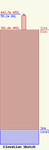
| Elevation Info |
Site Elevation: 381.6 meters (1252 ft) |
| Height of Structure: 54.9 meters (180 feet) |
| Overall Height Above Ground: 59.1 meters (194 feet) |
| Overall Height Above Mean Sea Level: 440.7 meters (1446 feet) |
| Owner Info | Gray Local Media, Inc.
4370 Peachtree Road, NE
Atlanta, GA 30319
(404) 266-8333
legalnotices@graymedia.com |
| Contact Info | Gray Local Media, Inc.
4370 Peachtree Road NE
Atlanta, GA 30319
Engineering Department
(404) 266-8333
legalnotices@graymedia.com |
