|
|
Antenna Structure Registration 1011405 |
 |
Registration Info | Registration Number: 1011405 |
| File Number: A1369360 |
| FAA Study: 2018-AWP-17609-OE |
| FAA Issue Date: 11/30/2018 |
| Status: Constructed |
| Date Constructed: 05/14/2007 |
| NEPA: N |
Structure Info
| Structure Type: GTOWER |
| Structure Coordinates: 38-37-50.2 N 120-51-24.9 W (NAD 83) |
| Structure Coordinates: 38-37-50.5 N 120-51-21.1 W (Converted to NAD 27) |
| Structure Address: On Hwy 49 3.5 Mi S |
| Structure City: El Dorado, CA |
| Structure County: El Dorado County |
| Painting & Lighting Info |
FAA Circular #: 70/7460-1L |
FAA Chapters: 4, 8, 12 |
Remarks: PRIOR STUDY 2014-AWP-9955-OE |
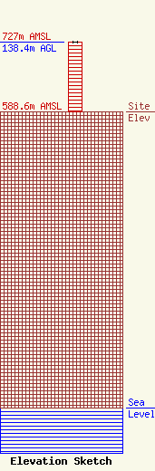
| Elevation Info |
Site Elevation: 588.6 meters (1931 ft) |
| Height of Structure: 137.2 meters (450 feet) |
| Overall Height Above Ground: 138.4 meters (454 feet) |
| Overall Height Above Mean Sea Level: 727 meters (2385 feet) |
| Owner Info | Crown Castle Towers 06-2 LLC
2000 Corporate Drive
Canonsburg, PA 15317
(724) 416-2400
Regulatory.Department@crowncastle.com |
| Contact Info | Crown Castle
2000 Corporate Drive
Canonsburg, PA 15317
Tom Anderson
(724) 743-6330
Tom.Anderson@crowncastle.com |
