|
|
Antenna Structure Registration 1011424 |
 |
Registration Info | Registration Number: 1011424 |
| File Number: A1184999 |
| FAA Study: 2019-ASO-32653-OE |
| FAA Issue Date: 11/14/2019 |
| Status: Constructed |
| Date Constructed: 02/07/2020 |
| NEPA: N |
Structure Info
| Structure Type: GTOWER |
| Structure Coordinates: 18-13-17.0 N 66-1-11.4 W (NAD 83) |
| Structure Coordinates: 18-13-24.2 N 66-01-12.8 W (Converted to NAD 27) |
| Structure Address: Carr 789 K 0 H 7 Bo Tomas De Castro 2 |
| Structure City: Caguas, PR |
| Structure County: Caguas Municipio |
| Painting & Lighting Info |
FAA Circular #: 70/7460-1L |
FAA Chapters: 3, 4, 5, 12 |
Remarks: PRIOR STUDY 2014-ASO-5053-OE |
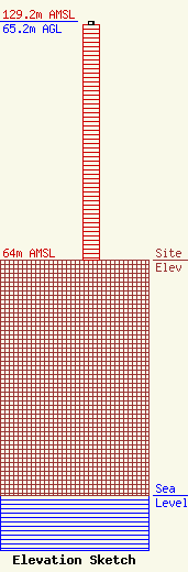
| Elevation Info |
Site Elevation: 64 meters (210 ft) |
| Height of Structure: 64.3 meters (211 feet) |
| Overall Height Above Ground: 65.2 meters (214 feet) |
| Overall Height Above Mean Sea Level: 129.2 meters (424 feet) |
| Owner Info | BORINQUEN BROADCASTING CO WVJP AM
207
CAGUAS, PR 00726
(787) 743-5790
SANDRARODRIGUEZ2008@YAHOO.COM |
| Contact Info | BORINQUEN BROADCASTING CO WVJP AM
207
CAGUAS, PR 00726
(787) 743-5790
SANDRARODRIGUEZ2008@YAHOO.COM |
