|
|
Antenna Structure Registration 1011487 |
 |
Registration Info | Registration Number: 1011487 |
| File Number: A0013711 |
| FAA Study: 96-ASW-3590-OE |
| FAA Issue Date: 02/25/1997 |
| Status: Constructed |
| Date Constructed: 01/01/1987 |
| NEPA: N |
Structure Info
| Structure Type: TOWER |
| Structure Coordinates: 35-32-51.0 N 97-29-31.0 W (NAD 83) |
| Structure Coordinates: 35-32-50.8 N 97-29-29.9 W (Converted to NAD 27) |
| Structure Address: 7416 N Kelly |
| Structure City: Oklahoma City, OK |
| Structure County: Oklahoma County |
| Painting & Lighting Info |
FCC Paragraph(s): 1, 3, 8, 17, 21 |
| Elevation Info |
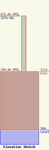
Site Elevation: 344.4 meters (1130 ft) |
| Height of Structure: 327 meters (1073 feet) |
| Overall Height Above Ground: 327 meters (1073 feet) |
| Overall Height Above Mean Sea Level: 671.4 meters (2203 feet) |
| Owner Info | OKLAHOMA CITY TOWER COMPANY
1000
OKLAHOMA CITY, OK 73101
(405) 840-5271
MDOWNS@IONET.NET |
