|
|
Antenna Structure Registration 1012273 |
 |
Registration Info | Registration Number: 1012273 |
| File Number: A0141398 |
| FAA Study: 93-AGL-1028-OE |
| FAA Issue Date: 05/17/1993 |
| Status: Constructed |
| Date Constructed: 07/07/1993 |
| FAA EMI: N |
| NEPA: N |
Structure Info
| Structure Type: TOWER |
| Structure Coordinates: 40-38-3.1 N 84-12-28.8 W (NAD 83) |
| Structure Coordinates: 40-38-02.9 N 84-12-29.0 W (Converted to NAD 27) |
| Structure Address: 19507 St Rt 501 |
| Structure City: Cridersvile, OH |
| Structure County: Auglaize County |
| Painting & Lighting Info |
FAA Circular #: 70/7460-1H |
FAA Chapters: 4, 7, 13 |
| Elevation Info |
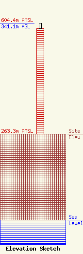
Site Elevation: 263.3 meters (864 ft) |
| Height of Structure: 324 meters (1063 feet) |
| Overall Height Above Ground: 341.1 meters (1119 feet) |
| Overall Height Above Mean Sea Level: 604.4 meters (1983 feet) |
| Owner Info | W A T C H TV COMPANY
3225 W ELM ST
LIMA, OH 45805
(419) 999-2824
watchmb@brt.bright.net |
| Contact Info | W.A.T.C.H. TV COMPANY
3225 WEST ELM ST
LIMA, OH 45805
MICHAEL BIRKEMEIER
(419) 999-2824
watchmb@brt.bright.net |
